

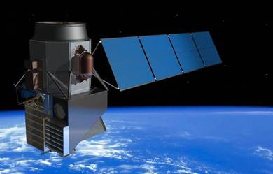
When we think of NASA, we mainly think of exploration beyond Earth, but the agency is just as dedicated to exploring and studying scientific processes here on our planet. NASA has been especially vigilant when it comes to monitoring the environment and collecting data on the effects of climate change.
From high tech tools aboard satellites to specialized drones, the following are ten cool projects the space agency has taken on over the past few years that are giving us a better understanding of how our world works and what we can do to protect it.


NASA Airborne Science Program
Using laser technology aboard three of its satellites, NASA captured the data necessary to make the world's first global map of forest height.
 |
| Ocean Surface Topography |
The Atmospheric Infrared Sounder (AIRS) instrument on NASA's Aqua spacecraft collects daily global CO2 measurements from our atmosphere. The data helps researchers understand how CO2 is distributed and transported, and can be used to develop better models to identify 'sinks,' regions of the Earth system that store CO2.
The ATTREX

(Airborne Tropical Tropopause Experiment) mission uses a modified Global Hawk unmanned aircraft to fly up to 65,000 feet above the tropical Pacific ocean and study "unexplored regions of the upper atmosphere for answers to how a warming climate is changing Earth. One such program is the Airborne Tropical Tropopause Experiment (ATTREX). They will use a modified Global Hawk unmanned aircraft (pictured above) to fly up to 65,000 feet above the tropical Pacific ocean and study "unexplored regions of the upper atmosphere for answers to how a warming climate is changing Earth." The drone will take off from and be operated by NASA's Dryden FlightResearch Center at Edwards Air Force Base in California and make 30-hour flights.
The International Space Station has just been outfitted with the SERVIR Environmental Research and Visualization System (ISERV), a commercial camera, telescope and pointing system, which will allow it to get even more high-definition photos of Earth. ISS SERVIR Environmental Research and Visualization System (ISERV) is an automated system designed to acquire images of the Earth's surface from the International Space Station (ISS).
Space Station for Educators
NASA for educatorsSpace Station for Kids
NASA for students
Space Station for Researchers
Research benefits

 |
| P-3B Fact Sheet |
“The first question is: what is the science that’s important to do? The second is: how do you do it?”
 |
| Hyperspectral Imager for the Coastal Ocean |
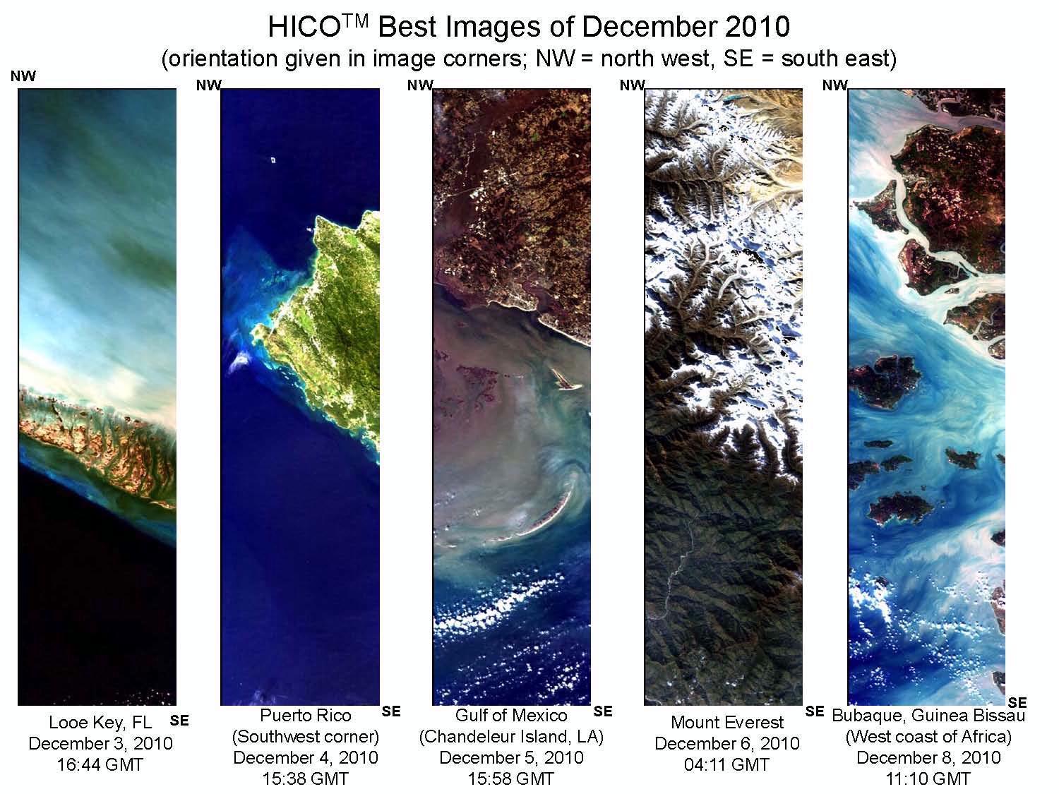
As a demonstration instrument, HICO is designed to collect one 50 x 200 km scene per orbit. A limited amount of this data will be available to academic and international scientists for their scientific studies. To become a HICO Data User and request data for your study requires a short proposal and signing a data use agreement. Team members will be asked to publish and share all data and results including presenting their results at an annual HICO Team Meeting. To access the forms and format for the proposal and apply visit the "Become a HICO Data User" webpage.
Mapping Ocean Dead Zones: NASA used its many satellites to create this first map of ocean dead zones, or low-oxygen zones in the ocean where creatures can't survive. The size and number of marine dead zones—areas where the deep water is so low in dissolved oxygen that sea creatures can’t survive—have grown explosively in the past half-century. Red circles on this map show the location and size of many of our planet’s dead zones. Black dots show where dead zones have been observed, but their size is unknown.
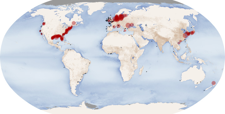

download large print resolution image (18 MB, PDF)
Aquatic and marine dead zones can be caused by an increase in chemical nutrients (particularly nitrogen and phosphorus) in the water, known as eutrophication. These chemicals are the fundamental building blocks of single-celled, plant-like organisms that live in the water column, and whose growth is limited in part by the availability of these materials.
Long-term changes in phytoplankton Productivity

NASA has perfected the use of heavy duty science balloons, like the SUPER-Tiger Balloon which recently set a record for longest flight for a balloon of its type after staying aloft for 55 days above Antarctica, carrying a new instrument that can measure elements heavier than iron within high-energy cosmic rays that bombard the Earth from all around the Milky Way galaxy. The Super Trans-Iron Galactic Element Recorder (Super-TIGER) balloon, one of three NASA science balloons recently launched above Antarctica, has broken two different records for flight duration all while collecting some cool scientific data.
NASA's Wallops Flight Facility: Balloon Technology Collection
Washington University in St. Louis WUSTL astrophysicists have received a five-year, $3,225,740 grant from the National Aeronautics and Space Administration (NASA) to design and build Super-TIGER — a Trans-Iron Galactic Element Recorder — and then fly it aboard a high-altitude balloon over Antarctica to collect rare atomic particles called galactic cosmic rays. W. Robert Binns, Ph.D., research professor of physics in Arts & Sciences, and the high-energy astrophysics group in the Department of Physics and the McDonnell Center for the Space Sciences, received the grant, titled “Super-TIGER: A Very-Large-Area, High-Resolution Trans-Iron Cosmic Ray Investigation.”
Super-TIGER’s first flight in search of the origin of cosmic rays is planned for December 2012.
2012 Super-TIGER Launch
2012 Super-TIGER Flight Tracker
Rough guide to Super-TIGER watching Washington University in St. Louis
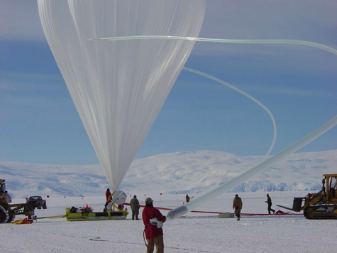
W. Robert Binns, PhD, principal investigator of the Super-TIGER experiment and research professor of physics at Washington University in St. Louis.
The Super-TIGER experiment is a collaboration of Washington University in St. Louis, the California Institute of Technology and NASA’s Goddard Space Flight Center. The team also includes people from the University of Minnesota and NASA’s Jet Propulsion Laboratory. the balloon’s maker Raven Aerostar.
Check out the interactive diagram of the TIGER detector or the animation of the detector in action.
Mathematical Doodling
 |
| Anatomy of a TIGER |
Cosmic rays first became an object of curiosity at the turn of the century when the scientific world was agog with discoveries of different types of invisible radiation, including electrons, X rays, and emanations from radioactive elements.
Scientists experimenting with the new forms of radiation quickly discovered that some high-energy radiation was able to reach detectors protected by lead shielding. Where did this penetrating radiation come from? The belief spread that it was emitted by radioactive material in Earth’s crust.
That view was overturned by the Austrian scientist Victor Hess, who demonstrated, during 10 high-altitude balloon flights, that the higher one went, the more penetrating radiation one encountered. The source, then, had to be extraterrestrial (cosmic) rather than earthly.
Today we know that 90 percent of cosmic rays are hydrogen nuclei (the protons), 9 percent are helium nuclei, and the remaining 1 percent are the nuclei of heavier elements.
Once scientists understood what cosmic rays were, the next question was: where do they come from?
There are two parts to that question, says Martin Israel, PhD, professor of physics at Washington University and co-investigator on Super-TIGER. The first is where does all the energy come from?
The second part of the question is: where is the energy loaded onto the particles?





